---
title: "Three Days Apart: How Costa Rica and Chile Remember Independence"
description: Explore Costa Rica and Chile’s September traditions, then discover how Central America, South America, the Atacama and Rapa Nui differ.
image: https://blog.nayararesorts.com/hubfs/CDBDF9C7-0475-40BC-A49B-D98B3780D27C.jpg
---
[Blog](https://blog.nayararesorts.com/)
[](https://nayararesorts.com/)
SUBSCRIBE
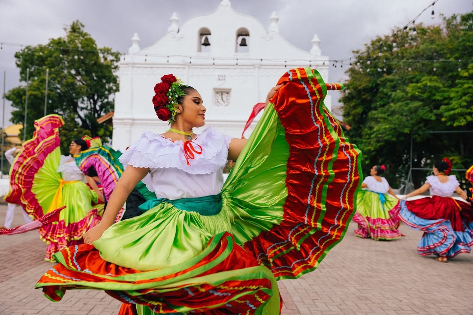
# Three Days Apart: How Costa Rica and Chile Remember Independence
[Albert Ghitis](https://blog.nayararesorts.com/author/albert-ghitis-1)
Aug 28, 2026
Costa Rica and Chile celebrate independence three days apart, but the dates remember two very different political histories, a contrast that becomes even more complex when Chile extends west to Rapa Nui.
Key Findings
28 days
Passed before the September 15 declaration signed in Guatemala reached Costa Rica on October 13, 1821.
7+ years
Separate Chile's First Government Junta in 1810 from its formal independence proclamation in 1818.
3,700 km
Separate Rapa Nui from continental Chile, placing a Polynesian homeland within Chile's national borders.
In This Article
6 min read
[01Three Days in September](https://blog.nayararesorts.com/three-days-apart-how-costa-rica-and-chile-remember-independence#three-days) [02Costa Rica's 28-Day Story](https://blog.nayararesorts.com/three-days-apart-how-costa-rica-and-chile-remember-independence#costa-rica) [03Chile Celebrates the Beginning](https://blog.nayararesorts.com/three-days-apart-how-costa-rica-and-chile-remember-independence#chile) [04What “Latin America” Conceals](https://blog.nayararesorts.com/three-days-apart-how-costa-rica-and-chile-remember-independence#central-america) [05Chile Beyond South America](https://blog.nayararesorts.com/three-days-apart-how-costa-rica-and-chile-remember-independence#rapa-nui) [06Before There Were Republics](https://blog.nayararesorts.com/three-days-apart-how-costa-rica-and-chile-remember-independence#before-republics) [07What a Border Cannot Tell You](https://blog.nayararesorts.com/three-days-apart-how-costa-rica-and-chile-remember-independence#border) [08Frequently Asked Questions](https://blog.nayararesorts.com/three-days-apart-how-costa-rica-and-chile-remember-independence#faq)
The Opening Scene
## Three Days in September
**In short:** Costa Rica's September 15 commemorates a Central American declaration signed in Guatemala in 1821. Chile's September 18 marks the First Government Junta of 1810, the beginning of an independence process completed years later.
At six in the evening on September 14, children across Costa Rica step into the dark carrying handmade lanterns. Three nights later, Chile celebrates *el Dieciocho* with fondas, cueca and tables crowded with food.
Only three days separate the celebrations. Their histories are far less alike: Costa Rica remembers a declaration whose news took nearly a month to arrive, while Chile celebrates the start of a political transformation rather than the date of formal independence.
***Latin America may be one region on a map. It has never been one story.***
Three Days in September
September 14
Costa Rica
The national anthem and evening *faroles*.
September 15
Costa Rica
The 1821 Central American declaration is commemorated.
September 18
Chile
The First Government Junta of 1810 is commemorated.
Three dates, two national traditions and two different independence histories.
Costa Rica · September 15
## The News That Took 28 Days to Arrive
On September 15, 1821, political leaders in Guatemala City signed the [Act of Independence of Central America](https://www.museocostarica.go.cr/exhibicion-virtual-bicentenario/grandes-aniversarios/). Today, Costa Rica, Guatemala, El Salvador, Honduras, and Nicaragua all commemorate that date. Costa Rica did not receive the news until October 13, 28 days after the declaration was signed.
The delay mattered. Communities still had to decide what independence meant and what political arrangement should follow. On October 29, representatives meeting in Cartago signed a local act declaring independence from the Spanish government, creating a lasting distinction between the regional declaration Costa Rica celebrates and the local decision that followed.
Modern Costa Rica turned that slow-moving news into ritual. Each September, the [Independence Torch travels south through Central America](https://www.mep.go.cr/noticias/antorcha-independencia-inicio-recorrido-costa-rica), and on September 14 children carry [*faroles* through towns and schoolyards](https://www.mep.go.cr/noticias/noche-desfile-faroles).
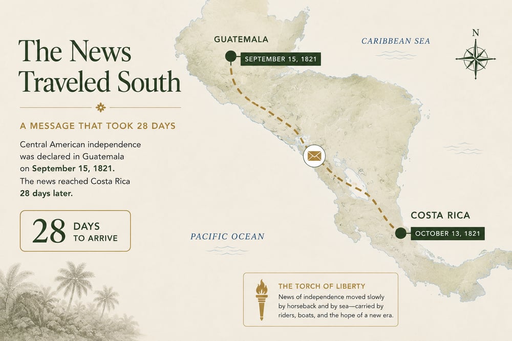
The News Traveled South · Central America, September to October 1821.
> News that once took 28 days to arrive is now carried hand to hand as light.
Chile · September 18
## Chile Celebrates the Beginning, Not the End
Chile's September 18 celebration does not mark formal independence. It commemorates the [First Government Junta](https://www.memoriachilena.gob.cl/602/w3-article-593.html), formed in Santiago in 1810 while Napoleon's invasion had thrown Spain into crisis and King Ferdinand VII remained captive.
The break was not yet complete. The junta still professed loyalty to the Spanish king, and Chile then entered years of political fracture, royalist reconquest, and war. Bernardo O'Higgins proclaimed independence on February 12, 1818.
Yet September 18 became the country's great national celebration because public memory often settles on the moment a different future first became possible, not the day the process formally ended.
Today's [*Fiestas Patrias*](https://www.archivonacional.gob.cl/noticias/tradicion-de-fiestas-patrias) fill the country with fondas, ramadas, cueca, empanadas, and anticuchos. September 19 adds the Day of the Glories of the Army and the national military parade.
The Limits of a Regional Label
## What “Latin America” Conceals
“Latin America” is useful because it names real connections: histories of Iberian colonization, Indigenous survival, African diaspora, republican independence, migration and exchange. But it is a historical and cultural framework, not a single geography.
Costa Rica's place on the Central American isthmus tied it to the former Captaincy General of Guatemala and shaped the route by which the 1821 declaration traveled south. Continental Chile developed along another axis entirely, on the Pacific edge of South America between the Andes and the ocean.
The distinction matters because shared regional history becomes more legible, not less, when those different geographic worlds remain visible.
One Regional Name, Three Geographic Contexts
Central American Isthmus
Costa Rica
Its September 15 history belongs to the political geography of Central America and the former Captaincy General of Guatemala.
Pacific South America
Continental Chile
Its independence process unfolded within an Andean-Pacific world shaped by the mountains, the ocean and the continent’s western edge.
Polynesian Pacific
Rapa Nui
A Polynesian homeland within the borders of a South American state, complicating any simple continental account of Chile.
“Latin America” connects these places historically; it does not erase the distinct geographic and cultural worlds the term contains.
Chile · Rapa Nui · Polynesia
## But Chile Doesn't End in South America
Look at a conventional map of Chile and the eye follows the country south: Atacama, Santiago, Patagonia, Cape Horn. Then move approximately 3,700 kilometers west into the Pacific.
There is Rapa Nui.
Rapa Nui, often called Easter Island, is politically part of Chile but geographically and culturally Polynesian. Its first settlers crossed the Pacific from Eastern Polynesia, and their descendants developed a distinct society, language and monumental tradition expressed in the island's *ahu* and moai.
In 1888, the [Agreement of Wills](https://www.patrimoniocultural.gob.cl/noticias/ministerio-de-las-culturas-entrega-historico-acuerdo-de-voluntades-de-1888-representantes) established a political relationship between Rapa Nui and Chile whose meaning and implementation [remain contested](https://www.iwgia.org/en/articles/iw-2025-rapa-nui).
**Geography places Rapa Nui in Polynesia. Political history placed it within Chile.**
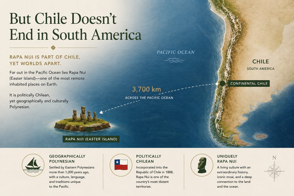
Rapa Nui lies approximately 3,700 kilometers west of continental Chile.
The Older Histories
## Before There Were Republics
Independence is only one layer of these places. The [National Museum of Costa Rica traces human presence in the territory back more than 12,000 years](https://www.museocostarica.go.cr/divulgacion/articulos-educativos/historia-profunda/); around San Pedro de Atacama, archaeological sites reach back more than two millennia within a [living Lickanantay world](https://chile.travel/en/blog/take-note-three-experiences-you-must-have-in-san-pedro-de-atacama/); and on Rapa Nui, Polynesian language, families and cultural memory remain alive. Independence created modern states. It did not create the peoples, languages, or relationships to land those states came to contain.
The Larger Meaning
## What a Border Cannot Tell You
Three days separate Costa Rica's and Chile's national celebrations. Behind them lie two different paths to independence, two geographic regions and, within Chile's borders, a Polynesian homeland far out in the Pacific.
“Latin America” connects these histories, but national borders and regional labels cannot explain every people, language, or cultural world they contain.
***The better question is what worlds a map leaves out.***
Frequently Asked Questions
## Costa Rica and Chile Independence Days
When is Costa Rica's Independence Day?+
September 15. The evening of September 14 is marked by the national anthem and traditional *faroles*, with civic celebrations continuing the next day.
Why does Costa Rica celebrate September 15 if news of independence arrived in October?+
September 15 commemorates the 1821 Central American declaration signed in Guatemala City. The document reached Costa Rica on October 13, and representatives in Cartago made a local political decision later that month.
When is Chile's Independence Day?+
Chile's principal national celebration is September 18, marking the First Government Junta of 1810. Formal independence was proclaimed in 1818.
Is Costa Rica in Central America or South America?+
Costa Rica is in Central America. Chile is in South America.
Is Easter Island part of Chile?+
Yes. Rapa Nui, often called Easter Island, is part of Chile and lies about 3,700 kilometers from continental Chile. Geographically and culturally, it is Polynesian.
Is September fall in Costa Rica and Chile?+
Not in the U.S. sense. Costa Rica is tropical, so wet and dry seasons are more useful distinctions. Chile is in the Southern Hemisphere, where September begins spring.
About the Author
## [Albert Ghitis](https://blog.nayararesorts.com/author/albert-ghitis-1)
Digital Marketing · Nayara Resorts
Albert Ghitis leads digital marketing at Nayara Resorts, overseeing editorial and newsletter strategy, search and AI discovery, and paid digital media. He is also the host of *Nayara Horizons: Beyond Travel*, a podcast exploring the people, places and ideas shaping travel today.
[More from Albert Ghitis →](https://blog.nayararesorts.com/author/albert-ghitis-1)
Rainforest, Desert and Pacific
## Travel Beyond the Label
Discover the distinct landscapes, histories and living cultures within the countries Nayara calls home.
[Check Availability](https://nayararesorts.com/#/booking/destination/dates?data=\('h6hd*a5dt*fs-~r6at!2~cn!0~cg-~al3po*co*gp*rn4ry*rk*re-~rr*ss4ax!0~cy*ds!\('p5ls*as*st*h5ee.\)~my3s5c5ne.\)*.~-1%5D.!null1!%5B3!false~4-\)%5D~5e*6s1\('%0165431.-*_)[Explore Our Resorts](https://nayararesorts.com/our-resorts/)
Sources and Further Reading
- [Museo Nacional de Costa Rica: Grandes Aniversarios](https://www.museocostarica.go.cr/exhibicion-virtual-bicentenario/grandes-aniversarios/)
- [Costa Rica Ministry of Education: Independence Torch](https://www.mep.go.cr/noticias/antorcha-independencia-inicio-recorrido-costa-rica)
- [Costa Rica Ministry of Education: Lantern Parade](https://www.mep.go.cr/noticias/noche-desfile-faroles)
- [Museo Nacional de Costa Rica: Historia Profunda](https://www.museocostarica.go.cr/divulgacion/articulos-educativos/historia-profunda/)
- [Biblioteca Nacional de Chile: First Government Junta](https://www.memoriachilena.gob.cl/602/w3-article-593.html)
- [Biblioteca Nacional de Chile: Revolution and War of Independence](https://www.memoriachilena.gob.cl/602/w3-article-692.html)
- [Archivo Nacional de Chile: Fiestas Patrias Tradition](https://www.archivonacional.gob.cl/noticias/tradicion-de-fiestas-patrias)
- [Chile Travel: Fiestas Patrias Culture and Food](https://chile.travel/en/blog/fiestas-patrias-in-chile/)
- [Chile Travel: Lickanantay Experiences in San Pedro de Atacama](https://chile.travel/en/blog/take-note-three-experiences-you-must-have-in-san-pedro-de-atacama/)
- [Chile National Cultural Heritage Service: The 1888 Agreement of Wills](https://www.patrimoniocultural.gob.cl/noticias/ministerio-de-las-culturas-entrega-historico-acuerdo-de-voluntades-de-1888-representantes)
- [UNESCO: Rapa Nui National Park](https://whc.unesco.org/en/list/715/)
- [National Geographic Society: North America and Central America](https://education.nationalgeographic.org/resource/north-america-physical-geography/)
- [IWGIA: The Indigenous World 2025, Rapa Nui](https://www.iwgia.org/en/articles/iw-2025-rapa-nui)
[](https://blog.nayararesorts.com/rom-deadly-sin-to-rainforest-royalty-the-soul-of-nayara)
## [Luxury Resorts Rooted in Nature: The Nayara Story](https://blog.nayararesorts.com/rom-deadly-sin-to-rainforest-royalty-the-soul-of-nayara)
Sep 3, 2025
[](https://blog.nayararesorts.com/the-top-10-travel-trends-of-2026)
## [The Top 10 Travel Trends of 2026](https://blog.nayararesorts.com/the-top-10-travel-trends-of-2026)
Jan 7, 2026
[](https://blog.nayararesorts.com/walking-giants-the-hito-family-the-future-of-easter-island)
## [How Nayara Hangaroa Leads Regeneration on Rapa Nui](https://blog.nayararesorts.com/walking-giants-the-hito-family-the-future-of-easter-island)
Nov 5, 2025
- [Nayara Gardens](https://nayaragardens.com/)
- [Nayara Springs](https://nayarasprings.com/)
- [Nayara Tented Camp](https://nayaratentedcamp.com/)
- [Nayara Alto Atacama](https://www.altoatacama.com/)
- [Nayara Hangaroa](https://www.hangaroa.cl/)
- [Nayara Bocas Del Toro](https://bocasbali.com/)
-
-
-
-
-
-
- [Costa Rica +506 2479-1600](tel:+50624791600)
- [US +1 844-865-2002](tel:+18883322961)
- [UK +44 1617918120](tel:+441617918120)
```json
{
"@context" : "https://schema.org",
"@type" : "BlogPosting",
"author" : {
"@type" : "Person",
"name" : "Albert Ghitis",
"url" : "https://blog.nayararesorts.com/author/albert-ghitis-1"
},
"dateModified" : "2026-09-10T20:40:47.225Z",
"datePublished" : "2026-08-28T20:35:18.000Z",
"headline" : "Three Days Apart: How Costa Rica and Chile Remember Independence",
"image" : [ "https://blog.nayararesorts.com/hubfs/CDBDF9C7-0475-40BC-A49B-D98B3780D27C.jpg" ],
"mainEntityOfPage" : {
"@id" : "https://blog.nayararesorts.com/three-days-apart-how-costa-rica-and-chile-remember-independence",
"@type" : "WebPage"
},
"publisher" : {
"@type" : "Organization",
"logo" : {
"@type" : "ImageObject",
"url" : "https://blog.nayararesorts.com/hubfs/Captura%20de%20pantalla%202023-04-13%20a%20la(s)%2010.55.13.png"
},
"name" : "Nayara Resorts"
}
}
```
```json
{
"@context" : "https://schema.org",
"@type" : "BlogPosting",
"author" : {
"@type" : "Person",
"description" : "Albert Ghitis leads digital marketing at Nayara Resorts, overseeing editorial and newsletter strategy, search and AI discovery, and paid digital media. He is also the host of Nayara Horizons: Beyond Travel, a podcast exploring the people, places and ideas shaping travel today.",
"jobTitle" : "Digital Marketing",
"name" : "Albert Ghitis",
"url" : "https://blog.nayararesorts.com/author/albert-ghitis-1",
"worksFor" : {
"@type" : "Organization",
"name" : "Nayara Resorts",
"url" : "https://nayararesorts.com/"
}
},
"headline" : "Three Days in September: What Costa Rica and Chile Reveal About Latin America",
"mainEntityOfPage" : {
"@id" : "https://blog.nayararesorts.com/three-days-apart-how-costa-rica-and-chile-remember-independence",
"@type" : "WebPage"
},
"publisher" : {
"@type" : "Organization",
"name" : "Nayara Resorts",
"url" : "https://nayararesorts.com/"
}
}
```